Traveling Salesman Problem with Genetic Algorithm
Solving the Traveling Salesman Problem with a Genetic Algorithm
The Traveling Salesman Problem (TSP) is a classic optimization challenge: given a list of cities, find the shortest possible route that visits each city exactly once and returns to the starting point. In my latest project, I tackled this problem for 9 Moroccan cities using a Genetic Algorithm (GA). Here’s a deep dive into the project, how it works, and how you can try it yourself!
You can find the full code and resources in my GitHub repository: github.com/ammarlouah/TSP_GA.
What’s the Project About?
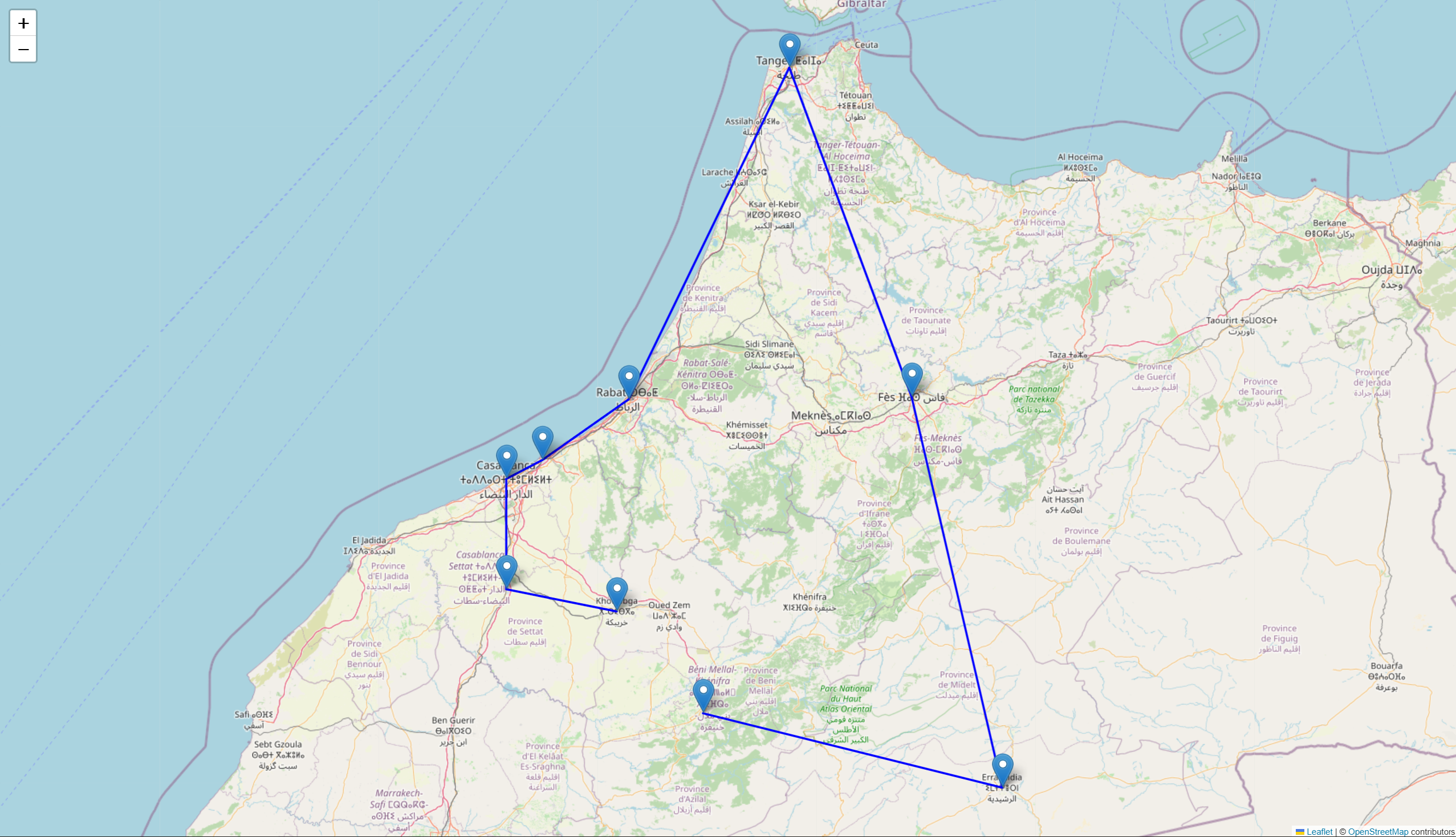
This project uses a Genetic Algorithm to solve a TSP instance for the following Moroccan cities:
- Khouribga (starting point)
- Settat
- Beni Mellal
- Tangier
- Errachidia
- Fes
- Rabat
- Casablanca
- Mohammedia
The solution:
- Fetches real-world city coordinates from OpenStreetMap.
- Uses the OpenRouteService API to compute realistic road distances between cities.
- Applies a Genetic Algorithm to find an optimized route.
- Visualizes the best route on an interactive map using Folium.
The result? A neat HTML map showing the best route and a JSON file with cached distance data for efficiency.
What’s Inside the Repository?
The repository (github.com/ammarlouah/TSP_GA) contains:
generate_data.ipynb: A Jupyter notebook to fetch city coordinates and compute distances, saving them tocity_distances.json.TSP_GA.ipynb: The main notebook implementing the GA (population generation, fitness evaluation, selection, crossover, mutation, elitism) and generating the interactive map (best_route_map.html).city_distances.json: Cached distance matrix to avoid repeated API calls.best_route_map.html: Interactive map showing the best route found.requirements.txt: Python dependencies..env: Local file (not tracked) for storing your OpenRouteService API key.README.md: Detailed setup and usage instructions.
How Does the Genetic Algorithm Work?
The GA mimics natural evolution to find a good solution:
- Population: A set of random routes (potential solutions).
- Fitness: Evaluates each route based on total distance (shorter is better).
- Selection: Picks the best routes to “breed” the next generation.
- Crossover: Combines parts of two parent routes to create new ones.
- Mutation: Randomly tweaks routes to maintain diversity.
- Elitism: Preserves the best routes to ensure quality improves over generations.
You can tweak parameters like population size, number of generations, mutation rate, and more in the TSP_GA.ipynb notebook to experiment with performance.
How to Run It on Your Machine
Want to try it out? Here’s how to get started:
- Clone the Repository:
1 2
git clone https://github.com/ammarlouah/TSP_GA.git cd TSP_GA - Set Up a Virtual Environment (optional but recommended):
1
2
python -m venv .venv
source .venv/bin/activate  # On Windows: .venv\Scripts\activate
- Install Dependencies:
1
pip install -r requirements.txt
Required packages include
numpy,pandas,folium,requests,python-dotenv, andosmnx. - Get an OpenRouteService API Key:
- Sign up at openrouteservice.org for a free API key.
- Create a
.envfile in the project root with:1
API_KEY=your_openrouteservice_api_key_here
- Generate Distance Data:
- Open
generate_data.ipynbin Jupyter Notebook or JupyterLab and run all cells. - This creates or updates
city_distances.jsonwith the distance matrix.
- Open
- Run the Genetic Algorithm:
- Open
TSP_GA.ipynband run all cells. - This reads
city_distances.json, runs the GA, and generatesbest_route_map.html.
- Open
- View the Result:
- Open
best_route_map.htmlin a web browser to see the interactive route map. - Or from the terminal:
1
open best_route_map.html  # On Windows: start best_route_map.html
- Open
Sample Output
After running the GA, you’ll get:
- Interactive Map:
best_route_map.htmlshows the best route with city markers and a polyline. - Distance Matrix:
city_distances.jsonstores the distances for reuse. - Total Distance: Printed in the notebook (varies due to GA randomness).
Tips and Troubleshooting
- API Limits: The free OpenRouteService plan has rate limits. If you hit them, add delays in
generate_data.ipynbor reuse the cachedcity_distances.json. - Reproducibility: The GA involves randomness. Set a fixed random seed in
TSP_GA.ipynbfor consistent results. - Adding Cities: To include more cities, update
generate_data.ipynband ensure the distance matrix aligns with the GA code. - Parameter Tuning: Experiment with GA parameters (e.g.,
population_size,mutation_rate) inTSP_GA.ipynbto optimize results.
Get Involved
Want to contribute or have ideas?
- Open an issue on the GitHub repo for bugs or suggestions.
- Experiment with different GA strategies (e.g., selection methods, crossover types) and share your findings!
License
This project is licensed under the MIT License. Check the LICENSE file in the repository for details.
Let’s Connect
Got questions or want to chat about the project? Reach out to me at ammarlouah9@gmail.com or open an issue on GitHub. Happy coding!